
THE HISTORY OF THE DALTON HIGHWAY
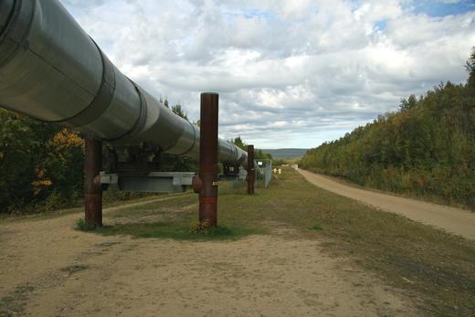
The Dalton Highway is one of the most famous—and dangerous—roads in Alaska, used by thousands of people each year. Connecting the city of Fairbanks in the Alaskan Interior to the oil fields at Prudhoe Bay along the North Slope, the Dalton Highway is a vital transportation artery for men and materials. In the years since its construction, it has also become a popular tourist attraction due to its scenic vistas, the Trans-Alaska Pipeline System (which it parallels for much of its length), and the fact that it ends in the Arctic Circle.
The construction of the Dalton Highway was fraught with danger and stymied by politics, and it stands today as one of Alaska’s most important roads. Here is a brief history of the Dalton Highway.
The History of the Dalton Highway
The Dalton Highway’s existence is intimately tied to the Alaskan oil industry. As far back as the early 19th century, explorers and surveyors were aware of the presence of oil in the North Slope, Alaska’s Arctic coast. The Iñupiat people of northern Alaska were known to mine oil-saturated peat, which they called “pitch,” using it as fuel to provide light and heat. In 1836, Thomas Simpson, an officer of the Hudson’s Bay Company, observed oil seepages along the North Slope during an expedition.
After World War I, interest in searching out oil deposits in Alaska increased due to the U.S. Navy converting its ships to use oil for fuel instead of coal. President Warren Harding established a series of Naval Petroleum Reserves in the U.S., the fourth of which incorporated Prudhoe Bay and much of Alaska’s North Slope. Initial oil exploration of the area was carried out by the U.S. Geological Survey from 1923 to 1925, but was limited due to primitive technology at the time.
Interest in the North Slope was renewed during World War II, with the U.S. Navy funding surveys across the region from 1943 to 1953, when funding was suspended. While these surveys uncovered oil deposits, such as the Alpine and Umiat oil fields, they were deemed too expensive to develop. In 1957, Richfield Oil Corporation (which would later be renamed Atlantic Richfield and ARCO) drilled a large oil well near Kenai in southern Alaska, which sparked new interest in locating oil deposits along the North Slope.
In 1967, Atlantic Richfield began surveys of the Prudhoe Bay region, eventually drilling two successful oil wells the following year. It was estimated that the Prudhoe Bay oil field held more than 25 billion barrels of oil, making it by far the largest oil field in the U.S. and North America. However, extracting the oil and shipping it to world markets was a logistical challenge. The Arctic Ocean was unsafe for oil tankers to sail to due to large quantities of sea ice, and the region was also sparsely populated, lacking ports for ships to arrive at.
It was determined that a pipeline was the only viable means of transporting oil from Prudhoe Bay, connecting it to ports on Alaska’s southern coast, which oil tankers could safely use. In 1969, the Trans-Alaska Pipeline System, a joint venture by British Petroleum, Humble Oil, and ARCO began preliminary studies on constructing a pipeline between Prudhoe Bay and the port city of Valdez. Construction was halted in 1970 after the Department of the Interior refused to issue a construction permit.
Opposition to the Trans-Alaska Pipeline System was driven by Native Alaskans and conservationists. Native Alaskans were concerned that the pipeline would infringe on their land rights, which the partnership dealt with by signing individual agreements with Native villages whose lands lay near or in the proposed path of the pipeline. Conservationists blocked the construction of the pipeline due to fears of environment damage caused by its construction.
Public opinion of the Trans-Alaska Pipeline System changed in 1973, when OAPEC announced an oil embargo against the U.S. due to its support of Israel in the Yom Kippur War. Because roughly a third of American oil was imported from foreign countries, the embargo had a dramatic effect, causing gas prices to skyrocket and shortages to become common. The Trans-Alaska Pipeline Authorization Act was passed into law later that year to allow construction and lessen America’s dependence on foreign oil.
Construction on the Trans-Alaska Pipeline System began in 1974 and ended in 1977. The Dalton Highway was constructed alongside it to serve as a support road due to a lack of road connections between Prudhoe Bay and the rest of Alaska. Oil extraction via the pipeline began in 1977, and the pipeline’s construction led to dramatic growth in the Alaskan economy.
Today, the Dalton Highway is largely used by truckers ferrying supplies between Prudhoe Bay and Fairbanks, and is also a well-known tourist attraction, as it allows motorists to view the Trans-Alaska Pipeline System easily. The road is known for its lack of human habitation, with the only towns along its route being Coldfoot, Wiseman, and Deadhorse, the road’s northern terminus. Fuel can be purchased at Coldfoot, Deadhorse, and the E.L. Patton Bridge, which traverses the Yukon River. Much of Deadhorse is off-limits to the public as the town’s roads are largely owned by private oil companies.
Much of the Dalton Highway is gravel due to the expense of maintaining roads in the harsh climate and the fear of permafrost damage caused by more advanced road construction techniques. Travelers are urged to bring survival gear due to the fact that the closest medical facilities are in Fairbanks and Deadhorse. Drivers are required to keep their headlights on at all times, even during the day, due to the road’s isolation and the presence of steep grades and sharp turns.
Wild animals are also known to roam the Dalton Highway at regular intervals. It is quite common to see moose or even the occassional brown bear on the way to the Arctic Circle. Both the Dalton Highway and the neighboring Alaska Pipeline were designed to allow animals to move freely around them.
Conclusion
The Dalton Highway and the Trans-Alaska Pipeline System remain central to the Alaskan economy and are important tourist attractions. While traversing the Dalton Highway can be dangerous to those who are unprepared, the highway’s natural beauty continues to lure many tourists from around the world who want to see the pipeline as well as the Arctic Circle. If you’re curious about the Dalton Highway, why not book a tour and see for yourself?